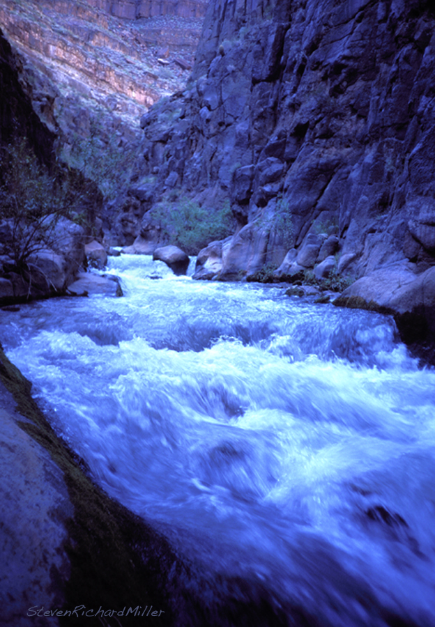
The Colorado River in the Grand Canyon – Tapeats Creek, Mile 133.7


Tapeats Creek! It’s a crystal-clear trout stream fed by springs that issue from below the North Rim, one of which is the spectacular Thunder River Spring which shoots out of a cave in a limestone cliff.

Tie-off in the cliff at the mouth of Tapeats Creek

Tie-off in the cliff at the mouth of Tapeats Creek

The mouth of Tapeats Creek. Camping is no longer allowed at the mouth.

Tapeats Creek. Camping is no longer allowed at the mouth. The lower camp is considerably less desirable (see below).

At the mouth of Tapeats Creek, view downstream of the diabase layer, capped by the Tapeats Sandstone

At the mouth of Tapeats Creek, view downstream of the diabase layer, capped by the Bass Limestone and Tapeats Sandstone

The diabase mentioned above was first encountered at the foot of Bedrock Rapid. It is an intrusive rock that squeezed in between two members of the Grand Canyon Supergroup – the Bass Limestone above and the Hotauta Conglomerate below. It is a “sill” – meaning it is a horizontal layer.

Tapeats Creek. I've caught trout out of the stream side hole seen here.

Tapeats Creek. I’ve caught trout out of the hole seen here.

Tapeats Creek, lower camp

Tapeats Creek, lower camp. Watch out for abrasion from your boats moving back and forth against the rocks.

A polished Bass Limestone rock found at the lower camp.

A polished Bass Limestone rock found at the lower camp.

Tapeats Creek. The lower gorge is cut through the diabase rock.

Tapeats Creek. The lower gorge is cut through the diabase rock.

Tapeats Creek exits its lower gorge a short ways upstream from the mouth. The trail to the upper valley climbs straight uphill near here, until it reaches the layered Bass Limestone. Look for an exposure of asbestos as this trail reaches the top of the diabase. This asbestos is the product of “contact metamorphism” – when the molten diabase made contact with the Bass Limestone, it turned serpentine inclusions in the limestone into asbestos.

Tapeats Creek, lower gorge, wide-angle view

Tapeats Creek, lower gorge, wide-angle view. The trail contours along the limestone ledges seen here.

133TapeatsFirstCottonwoods

The trail approaches the creek, and the first of the cottonwoods found in the upper valley

Cottonwoods line Tapeats Creek in the upper valley

Cottonwoods line Tapeats Creek in the upper valley

Tapeats Creek high water, summer 1980

Tapeats Creek high water, summer 1980

Red monkeyflowers beside Tapeats Creek

Red monkeyflowers beside Tapeats Creek

Prickly pear cactus

Prickly pear cactus

Trailing Four O'Clocks

Trailing Four O’Clocks

The Grand Canyon Supergroup is present in the upper valley. A barrel cactus is seen in the reddish Hakatai Shale, and the purplish cliff is the Shinumo Quartzite.

The Grand Canyon Supergroup is present in the upper valley. A barrel cactus is seen in the reddish Hakatai Shale, and the purplish cliff is the Shinumo Quartzite.

The Bass Limestone is seen in the foreground, with Shinumo Quartzite on the right and the Redwall Limestone beyond

The Bass Limestone is seen in the foreground, with Shinumo Quartzite on the right and the Redwall Limestone beyond

The

The “Red and White Place” is Shinumo Quartzite

The

The “Red and White Place” is Shinumo Quartzite

The

The “Red and White Place” is Shinumo Quartzite

A rattlesnake shows the characteristic arrowhead- shaped pit viper head.

A rattlesnake shows the characteristic arrowhead- shaped pit viper head.

View into upper Tapeats Creek, above where the trail to Thunder river branches off.

View into upper Tapeats Creek, from the branch to Thunder River.

You get to see a lot of the Grand Canyon Supergroup on your hike up Tapeats Creek – from the Bass Limestone to the Hakatai Shale to the Shinumo Quartzite. Notice, in the photo above, the tilted layers of the Shinumo Quartzite that are capped by the horizontal Tapeats Sandstone. The top of the Shinumo is an “erosional surface”, where, in this case, erosion leveled it out perfectly. Afterwards, the Tapeats was deposited along  the shores of an inland sea atop it. Tapeats Creek is the “type locality” for the Tapeats Sandstone – the place where it was first named.

Tapeats Creek runs through the Shinumo Quartzite, upstream of Thunder River confluenece

Tapeats Creek runs through the Shinumo Quartzite, upstream of Thunder River confluence

Tapeats Creek runs through the Shinumo Quartzite, upstream of Thunder River confluenece

Tapeats Creek runs through the Shinumo Quartzite, upstream of Thunder River confluence

Thunder River is fed by snowmelt that percolates into the limestone beneath the Kaibab Plateau of the North Rim, running downhill through a cave system, finally to exit in the Muav Limestone. Other springs feed the upper portion of Tapeats Creek, and such springs are found in other drainages. Thunder River drops in volume throughout the summer, and the cave that it exits can be entered when the water is low. This cave can be followed quite a ways back.

Thunder River

Thunder River

Thunder River, high water

Thunder River, high water, with water shooting out of both cave orifices

At the base of the upper falls, Thunder River

At the base of the upper falls, Thunder River

Thunder River upper falls

Thunder River upper falls

Laina Reynolds makes a scary step, on the climb to the mouth of the Thunder River cave

Laina Reynolds makes a scary step, on the climb to the mouth of the Thunder River cave

Thunder River cave mouth, with red monkeyflowers

Thunder River cave mouth, with red monkeyflowers

Just inside the Thunder River cave, where the stream divides in two

Just inside the Thunder River cave, where the stream divides in two

Kathy Miller deep in the Thunder River cave, photo by Peter Donahue

Kathy Miller deep in the Thunder River cave, photo by Peter Donahue

Rainbow at the base of the upper falls

Rainbow at the base of the upper falls

Many river runners continue to hike beyond the waterfalls of Thunder River, arriving eventually at Deer Creek, the next drainage downstream on the Colorado.

A downstream telephoto view from the mouth of Tapeats Creek. On the left is the dark diabase rock, next is the yellowish Muav Limestone and the main wall of Redwall Limestone.

A downstream telephoto view from the mouth of Tapeats Creek. On the left is the dark diabase rock, next is the yellowish Muav Limestone and the main wall of Redwall Limestone.

Note: This and prior posts on the subject of running the Colorado River in the Grand Canyon are excerpted from my iBook: “The Grand, the Colorado River in the Grand Canyon, a Photo Journey and Visual Guide, 2nd. edition”. The book costs $5.99 and is available from the iTunes Store, using this link: https://itunes.apple.com/us/book/the-grand/id672492447?ls=1

About Evensteven

I am a photographer and author, and live in Embudo, New Mexico, alongside the Rio Grande. I have published a book of photography and accompanying text on running the Colorado River in the Grand Canyon. The first (print) edition is out of print, but a second edition is available as an iBook (eBook) through the iTunes bookstore. All Grand Canyon, river and nature lovers will enjoy my book: The Grand: https://books.apple.com/us/book/the-grand/id672492447 I have also published six additional iBooks: 1. The Salt River: https://books.apple.com/us/book/the-salt-river/id12449222822. 2. Coyote Buttes: https://books.apple.com/us/book/coyote-buttes/id1271773201 3. Four Cornered, the Land: https://books.apple.com/us/book/four-cornered/id1384038899 4. Four Cornered, The Rivers: https://books.apple.com/us/book/four-cornered-book-two-the-rivers/id1402287568 5. Rio Marañon: https://books.apple.com/us/book/four-cornered-book-two-the-rivers/id1402287568 6. Rio Grande: https://books.apple.com/us/book/rio-grande-new-mexico/id1469126321
This entry was posted in Colorado River in the Grand Canyon, Photography and tagged , , , , , , , , , , , , , , , , , . Bookmark the permalink.

1 Response to The Colorado River in the Grand Canyon – Tapeats Creek, Mile 133.7

Leave a comment